
Ebro Delta Bays SPAIN
Overview
Description
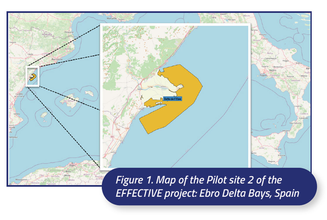
The Ebro Delta, located in the south of Catalonia (NE Spain), has an area of 320 km2 and represents one of the main wetland areas of the Western Mediterranean, due to its extension and ecological importance. The pilot site 2 of the EFFECTIVE project is the Ebro Delta Bays, Els Alfacs and El Fangar (Figure 1), which are part of the Natura 2000 area of the Ebro Delta connected with the Ebro Delta Natural Park (Figure 2). El Fangar is the northern bay, with an area of about 10 km2 and 4-5 m depth, and Els Alfacs is the southern bay, with an area of about 50 km2 and 5-6 m depth. Both are surrounded by shallow margins, less than 2 m of depth, which occupy more than half the total area. The bays conform to Cameron and Pritchard’s (1963) definition of estuaries, i.e. ‘ a semi-enclosed coastal body of water, which has a free connection with the open sea, and within which the water is measurably diluted with fresh water derived from land drainage’. Hydrodynamics in both bays are influenced by the surrounding Mediterranean Sea and seasonally by freshwater inflow through channels from an irrigation system for rice agriculture. This affects the load of nutrients and contaminants, which reach the highest concentrations near the mouth of the channels (especially in the sediments), and the presence of algal species including taxa which are capable of producing potent phycotoxins.
The Ebro Delta comprises a unique and fragile combination of coastal protected areas and it hosts several priority habitats (Cymodocea, Zostera and Ruppia seagrass beds, coastal lagoons, salt marshes, etc.) and species (Pinna nobilis, Aphanius iberus, Syngnanthus abaster, Phoenicopterus ruber, etc.) according to the EU Habitats and Birds Directives. It is also a representative case of coastal areas undergoing water quality problems having problems to fulfill the requirements of ecological quality of the Water Framework Directive and the Marine Strategy for transitional and coastal waters. The tidal amplitude is small, about 20 cm, and this favors water stratification.
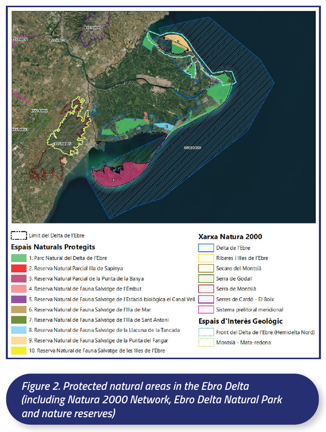
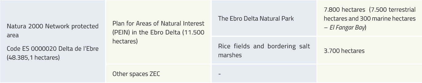
The Ebro Delta encompasses a wide array of natural environments (river, sea, bays, beaches, dunes, wetlands, riverine woodlands, coastal lagoons, etc.) and, along with the rice paddies, are home to a large number of organisms that have adapted to the different habitats. With the aim of seeking the coexistence between these natural assets and their use by the local population, and in response to demands from its inhabitants, the Government of Catalonia created the Ebro Delta Natural Park in 1983, which covers an area of 7.802 hectares. Initially, the protected area only included the areas of marshes, coastal lagoons, beaches and dune systems on the northern hemidelta but, in 1986, the protection area was expanded, including the southern hemidelta. Once expanded, the natural park covered 8.445 hectares of land and 564 marine hectares. The space also included the Natural Reserves of Punta de la Banya and Illa de Buda, where the level of protection is higher than the rest of the park. In 1992, the regional government approved the Plan for Areas of Natural Interest (PEIN) for the entire Catalan territory and this allowed the protected area of the Ebro delta to be expanded. The same area would finally be incorporated, in 2006, into the Natura 2000 Network (Figure 2).
The total protected area is 12.378 hectares on land and 35.647 hectares in the sea. In addition, the Ebro delta has other international protection figures, such as the Special Protection Area, SPA (1987), in accordance with the European Birds Directive (79/408/EEC), or the resolution in 1993 for inclusion in the Ramsar list of wetlands of international importance, especially as habitat for waterfowl. From May 2013, the whole Ebro Delta is also part of the Biosphere Reserve by UNESCO of Terres de l’Ebre.
Availability of MPA data
More information about the Natura 2000 Network, viewers and maps can be found in the following websites:
- • N2K ES0000020 dataforms (europa.eu)
https://natura2000.eea.europa.eu/Natura2000/SDF.aspx?site=ES0000020#7 - Natura 2000 Viewer (europa.eu)
https://natura2000.eea.europa.eu/ - Red Natura 2000 (RN2000) (miteco.gob.es)
https://www.miteco.gob.es/es/cartografia-y-sig/ide/descargas/biodiversidad/rn2000.html
The following website provides the information of the monitoring of marine biodiversity in the protected spaces of Cap de Creus Natural Park and Montgrí Natural Park, the Medes Islands and the Baix Ter: http://seguimentmari.cat/
The current Marine Biodiversity Monitoring program in the protected marine areas of Catalonia is coordinated by the University of Barcelona, with the participation of other institutions and research centers, such as the CSIC or IEO, and is commissioned and financed by the Department of Territory and Sustainability of the Generalitat of Catalonia.
The main objectives of this monitoring are:
- Evaluating the state of conservation of the populations and marine habitats of these region, in relation to the human activities carried out there, as well as to environmental factors
- Detecting risky situations for heritage (invasive species, effects of climate change, etc.)
- Increasing knowledge about this area and its species and habitats
- Developing new descriptors and management tools for the conservation of this area
- Facilitating a more sustainable management of marine resources
This existing monitoring plan provides useful information and data, disposing of annual scientific reports from 2017 until 2022. Within these reports, there is available data of recurrent monitoring of different species populations in the Medes Marine Partial Nature Reserve of the Montgrí Natural Park, the Medes Islands and the Baix Ter, Cap de Creus Natural Park and other zones of Special Conservation, such as the current status of bryozoans, red gorgonian (Paramuricea clavata), Caulerpa cylindrace (invasive algae), Posidonia oceanica, sponges, fishes, decapods and others. This continuous monitoring provides important information regarding the vulnerability of species to climate change.
Due to its biological and environmental importance, many projects have arisen in aid of the conservation of this MPA. For example, the MEDES project, emerged thanks to the collaboration agreement established between the Natural Park and the VIMAR group, with the support of Diving Center La Sirena, and they monitored monthly for several years the heterobranch molluscs population.
Another interessant monitoring project is the RESMED (marine reserve network and integrated management of cross-border Mediterranean coastal areas), in collaboration with the Barcelona University and co-founded by the ERDF. This project was carried out from 2019 until 2021, in aim to use acoustic telemetry techniques for studying the movements of fish and finding the characteristics of the ecosystems of this Mediterranean region, and findings indicate that the migratory patterns of various species establish significant population connectivity among distinct marine protected areas: including the Cerbère-Banyuls Marine Reserve, the Cap de Creus Natural Park, the Montgrí Natural Park, the Medes Islands and Baix Ter, as well as the Aiguamolls de lʼEmpordà Natural Park.
The Cartographic and Geological Institute of Catalonia (ICGC) developed a cartography viewer (Vissir3) using the “Open Source” OpenLayers library that allows the visualization of the pilot site and the download of the official cartography of Catalonia: ICGC – Vissir3
The marine phanerogams are habitats of great ecological importance and in which more than 700 different species are associated. The cartographic bases of the grasslands or meadows of marine phanerogams (Cymodocea nodosa, Zostera noltei and Zostera marina) known along the coast of Catalonia (including the Pilot 2 area) are available in the following website: Grasslands or meadows of marine phanerogams. Department of Climate Action, Food and Rural Agenda (gencat.cat)
The Institute of Agrifood Research and Technology (IRTA) carries out regularly the monitoring of water quality, phytoplankton, toxic algal blooms and contaminants of the two bays (https://www.marinemonitoring.org/el-psqam/#pll_switcher). The data is available under request.
The Ebro Delta Natural Park collects data on biodiversity (macrophytes, fishes, etc.) and bird populations annually. The data is available under request.
The following water data is collected by the Catalan Water Agency (ACA), which was also officially requested: physico-chemical parameters, nutrients, heavy metals and pesticides and various biological parameters (phytoplankton, macrophytes, benthos, etc.). The request also included data on the sediment of the Ebro Delta Bays (granulometry, organic matter, carbon, nutrients, pollutants, etc.).
Monitoring and Management
The Ebro delta’s ecosystems provide a vital staging point on bird migration routes and is home to a considerable number of birds listed on Annex I of the Birds Directive. More than 180,000 waterfowl winters and about 40.000 pairs nest in the delta. The Ebro Delta Natural Park carries out an annual monitoring of bird populations (wintering and breeding).
The Catalan Water Agency (ACA) regularly monitors the quality of the water in the Ebro Delta Bays and the water in the drainage canals of the rice fields that discharge into these bays. This monitoring includes some analysis of the sediment of the Ebro Delta Bays.
The Institute of Agrifood Research and Technology (IRTA) leads the programme for monitoring the water quality, Molluscs and Toxic Phytoplankton in the Seafood Production Areas of the Catalan Coast (Programa de Seguiment de la Qualitat de les Aigües, Mol·luscs i Fitoplàncton Tòxic a les Zones de Producció de Marisc del Litoral Català, PSQAM). This programme is executed by the Marine and Continental Waters programme of the IRTA by order of the General Directorate of Maritime Policy and Sustainable Fishing of the Government of Catalonia. This programme complies with EU Regulation 2019/627 in relation to the controls of live bivalve molluscs from classified production areas. The PSQAM started in 1990 and controls the microbiological quality of molluscs, the presence of toxin-producing plankton in the water and biotoxins and chemical pollutants in molluscs of the two bays (https://www. marinemonitoring.org/el-psqam/#pll_switcher).
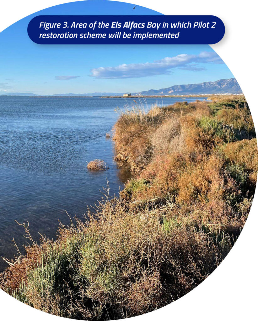
The restoration and management scheme that will be implemented in the Ebro Delta Bays pilot site, specifically in Els Alfacs (Figure 3), is a very shallow marine area for which there is no bathymetric data, since it is difficult to obtain information of this type. Thus, one of this Pilot’s first tasks within the framework of the EFFECTIVE project is the production of bathymetric information for this shallow area, using a Remotely Operated Vehicle (ROV), with the idea of expanding it further ahead to the rest of the bay with the aim of scaling up the restoration. Furthermore, the volume of the accumulated muds on the immediate shallow waters coming from the rice culture discharge will be estimated for seabed remediation.
According to the European Water Framework and the Marine Strategy Directives for transitional and coastal waters, related to the assessment of ecological quality within estuarine (transitional) and coastal systems, an integrated ecological monitoring will be conducted, including the biological and physico-chemical assessment of water bodies of the Pilot site 2 before and after restoration. On the one hand, macrophytes and macroalgae species and abundance as well as benthic invertebrates of this area will be assessed. This biological assessment will be complemented with previous biological data that was collected in the bays (e.g. phytoplankton, fishes, phanerogams, etc.). On the other hand, physico-chemical parameters of the water will be monitored periodically, i.e. temperature, salinity, pH, dissolved oxygen, turbidity, conductivity, chlorophyll a, solar radiation, suspended particulate matter, etc. Furthermore, other physico-chemical quality parameters of water will be monitored such as nutrients (nitrogen, phosphorus, carbon and silica), heavy metals and pesticides.
In addition, the sediment of the restoration area will also be characterized: the granulometry, the organic matter, carbon and nitrogen content, heavy metals and pesticides in the sediment will be evaluated before and after the restoration.
Threats and impact
The Ebro Delta is a vulnerable region and hugely complex in terms of its governance, given the large number of agents that converge around the same resources. Public agents on different levels (State, regional, local) coexist with a wide range of private agents (rice producers, fishers, hunters, tourism companies, foundations, NGOs), often with quite contrasting views.
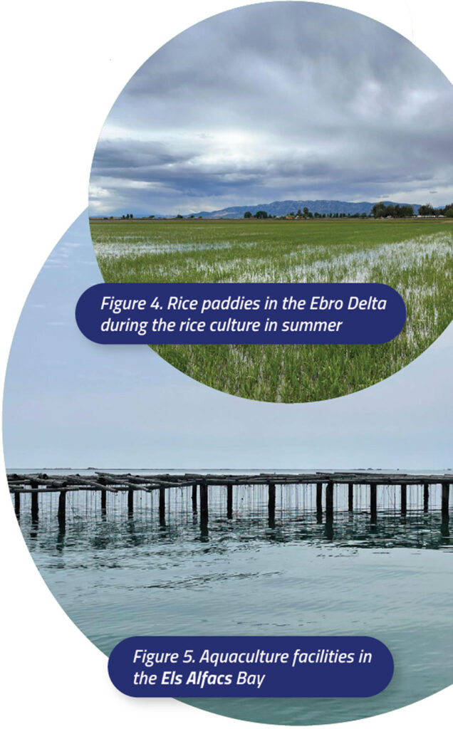
The Ebro Delta is mainly devoted to intensive agricultural activities, principally rice culture (Figure 4). In this area, river water plays a key role since rice fields require a constant water supply. Water is diverted from the river to the crops by an extensive network of irrigation channels which remain open from April to October, allowing river water to circulate to the fields and further the drainage from the paddy fields is discharged into the coastal bays.
This Pilot will address the degradation of coastal and marine habitats in a MPA representative of semi-enclosed coastal bodies (bays, coastal lagoons, estuaries, etc.) with intensive human activities (aquaculture, farming, fishing, tourism, etc.), including degraded littoral seabed habitats, and will develop and demonstrate protection and restoration solutions to upgrade and enhance the EU’s blue natural capital. This is a representative case of protected Mediterranean coastal water bodies subject to high human pressure, including the impact of climate change, especially the increasing frequency of extreme water temperatures in summer, in combination with other climate change pressures such as sea-level rise and acidification.
Over 20.000 hectares of the delta are dedicated to rice production and its associated drainage water feeds the two bays were intensive aquaculture (mostly mussel and oyster farms) and fisheries are conducted. This has led to a poor habitat and water quality that negatively impacts on estuarine and marine biodiversity as well as on aquaculture production (Figure 5). Chemicals, nutrients and organic matter coming from the farming activities are accumulated in the sediments of the bays and easily resuspended, leading to low oxygen and an excess of nutrients and turbidity, causing the deterioration of priority habitats such as Cymodocea nodosa, which is the preferred habitat of the endangered pen shell (Pinna nobilis) in the Ebro Delta. Moreover, the Els Alfacs and El Fangar bays suffer the effects of climate change such as sea level rise, increasing water temperature and acidification. Nowadays summer water temperature already reaches 30 ºC during heat waves.
EFFECTIVE restoration actions
Pilot 2 of the EFFECTIVE project is going to implement a management and restoration scheme that favors both biodiversity and aquaculture/fisheries while providing essential ecosystem services to mitigate the effects of the climate change in an established Marine Protected Area and Natura 2000 protected area.
The scheme combines the promotion of the colonization of helophytic communities on the first line of the shore to filter the rice discharge water (to reduce suspended sediment, nutrients, and pollutants) with the removal of the accumulated muds on the immediate shallow waters to allow Cymodocea nodosa and its associated habitat to recover. These actions will be beneficial for the aquaculture that is practiced in this same area by improving the water quality. Furthermore, artificial biotopes are going to be installed nearby the aquaculture facilities to better promote the community shift that we are seeking and to attract predators of the Blue Crab (Callinectes sapidus) to promote a top-down control of this invasive species that is threatening the aquaculture activity of the region. Finally, a system to increase the dissolved oxygen in the water surrounding the aquaculture activity will be tested to fight the effects of ocean acidification and the extreme temperatures reached in these water bodies during the summer.
This scheme will improve the conservation status of this MPA and Natura 2000 protected area by increasing its biodiversity, making it resilient to climate change and boosting the blue economy by moving towards a regenerative aquaculture. Another expected outcome of this scheme is the conservation of a critical endangered species of the Mediterranean Sea. Pinna nobilis is a giant bivalve that has seen its population reduced by a 99% since 2016 being the Ebro Delta bays the habitat that hosts its largest known colony. By improving the habitat quality of the bay – land interface we expect the Pinna nobilis to establish there too.
Not only the biodiversity and the economic activities of the region will be favored by the implementation of these actions, also several ecosystem services will be provided: carbon sequestration, coastal protection, food provisioning, water quality improvement and invasive species regulation. Overall, we aim to tackle the effects of climate change by ensuring the resilience of both the environmental and the economic values of the area.
Public Engagement and Citizen Science
The monitoring, protection and restoration actions carried out in this pilot site of the project are being co-created and co-designed by the relevant stakeholders to ensure the success of them. The Ebro Bioterritory Living Lab of the Climate Resilience Centre (Amposta, Spain) will be used to investigate and propose innovative management and restoration solutions, with the methodology of co-creation, co-design and co-management with socioeconomic agents. Furthermore, this co-creation space and its innovative methodology will be used to engage citizen participation with the project by disseminating it within a well-established network of collaborative projects related with active restoration, climatic assemblies and NBS design.
Some education and outreach initiatives available in the Pilot site:
- IEPAAC students (aquaculture training institute).
- Volunteer programmes of the Ebro Delta Natural Park and SEO/BirdLife.
- Blue Schools project (https://www.escolesblaves.cat/en/escoles-blaves/): it is an educational project aiming to bring marine research and the sea closer to school students and different audiences in the Terres de l’Ebre area region in southern Catalonia. This project promotes the introduction of marine sciences into schools, bringing current marine research closer to regions far from large cities and large research centers and with less access to scientific education events.
Some citizen science initiatives:
- Sea Watchers (Observadores del Mar) : is a Mediterranean citizen science portal for marine research that opens the way for citizen science to be a support tool for marine biodiversity monitoring and research projects. https://www.seawatchers.net/
- Natusfera: is an adaptation of iNaturalist developed by CREAF and Bineo Consulting, where you can upload your fauna and flora pictures to share with the community. https://natusfera.gbif.es/
- Citizens’ Observatory for Coast and Ocean Optical Monitoring (Citclops): aims to develop systems to retrieve and use data on seawater color, transparency and fluorescence, using low-cost sensors combined with people acting as data carriers, contextual information (e.g. georeferencing) and a community-based Internet platform, taking into account existing experiences (e.g. Secchi Dip-In, Coastwatch Europe and Oil Reporter). One of the two Citclops test areas was the Ebro Delta, NW Mediterranean. http://www.citclops.eu/
- The great eggcase hunt project: it quickly developed with the aim of getting as many people as possible out hunting for eggcases and recording their finds. Empty eggcases can help indicate species presence and diversity. https://www.sharktrust.org/greateggcasehunt
Institutional and legal framework
The area is a designated Natural Park in Catalonia and protected under the European Birds and Habitats Directives, the Ramsar Convention and UNESCO (Biosphere Reserve). All measures supporting the restoration of the river system and protecting its habitats of common interest contribute to achieving the objectives of the EU Water Framework Directive (2000/60/EC), Floods Directive (2007/60/EC), and Birds and Habitats Directives (2009/147/EC and 92/43/CEE).
The protected figures in the Ebro Delta are the following:
The management institutions in the Ebro Delta are listed below:
- Government of Catalonia. Department of Climate Action, Food and Rural Agenda.
- Government of Catalonia. Department of Territory. The Coastal Management Service.
- Government of Catalonia. Catalan Water Agency.
- Ministry for the Ecological Transition and the Demographic Challenge (Spanish Government). General Directorate for the Coast and the Sea.
- Ministry for the Ecological Transition and the Demographic Challenge (Spanish Government). Ebro Hydrographic Confederation.
- County Councils (Baix Ebre and Montsià).
- Local Municipalities.
Relevant EU projects for the MPA pilot site
Below are some ongoing EU projects, as well as completed at this Pilot site, with which synergies are being explored:
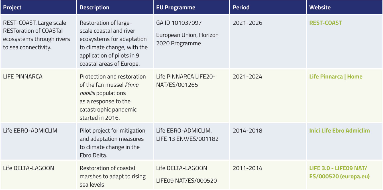
It is planned to expand this list of ongoing and completed projects carried out in this pilot area, both at European, national and regional level, in order to take advantage of prior knowledge and data as well as to promote synergies with the EFFECTIVE project.
Scientific publications
Raquel, Modino & Pascual-Fernandez, Jose. (2011). 30 Años de protección: turismo y pesca en las Illes Medes.
Ros i Aragonès, Joandomènec; Gili, Josep M. «Four decades of research on the Medes Islands». Contributions to science, 2016, Vol. 11, Núm. 1, p. 75-83, https://raco.cat/index.php/Contributions/article/view/313114.