
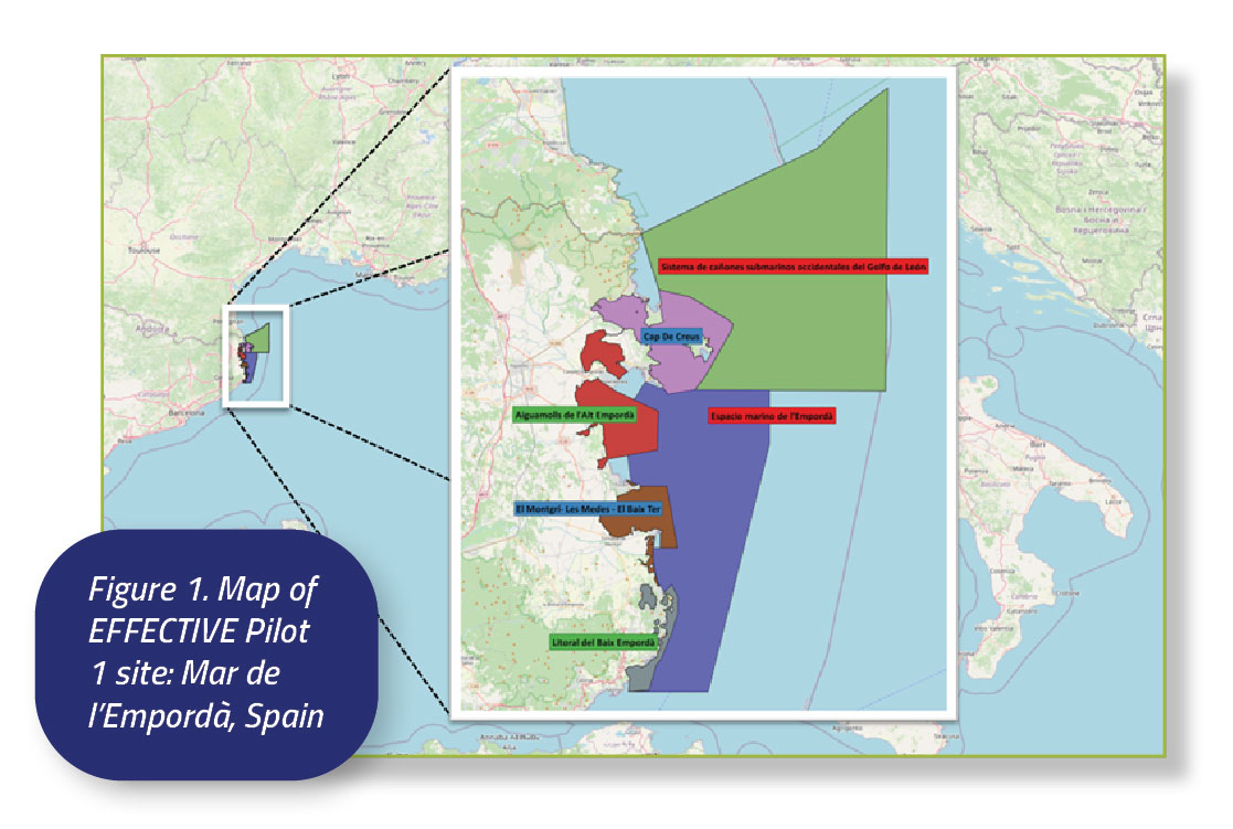
MAR DE L’EMPORDÀ SPAIN
Overview
Description
To the west, it borders the Mediterranean Sea, which is the coast of the Costa Brava, including the Medes Islands. To the north, the boundaries are in the municipalities of Torroella de Montgrí and L’Estartit, reaching to the municipality of L’Escala at the mouth of the Ter River. To the south, the boundary is the coastline, which also includes beach areas and wetlands near the Ter River.
http://atzavara.bio.ub.edu/geoveg/docs/Memoria_cartografia_habitats_Montgri2019.pdf
This site is a Key Biodiversity Area¹ located in Spain with 7 different MPAs coexisting, including Special Areas of Conservation (SAC) and Sites of Community Importance (SCI) under the EC Habitats Directive (92/43/EEC), Special Protection Areas (SPA) under the EC Birds Directive (2009/147/EC), and Specially Protected Areas of Mediterranean Importance (SPAMI) under the Barcelona Convention of 1976. In addition, a co-management and governance instrument does exist for this specific Natura 2000 area, called Litoral del Baix Empordà, which is named Taula de Cogestió Marítima del Litoral del Baix Empordà, and it is supported by the competent regional authority, and includes key stakeholders such as the scientific community, competent authorities and policymakers, civil society entities, and the blue socioeconomic and maritime sectors². Ecosystem richness of this pilot area is highlighted by the presence of important species such as red coral (C. rubrum) and gorgonians, P. oceanica and C. nodosa meadows, sponges, P. nobilis, H. hippocampus and A. antennatus.
• Parc Natural del Montgrí, les Illes Medes i el Baix Ter (2010)
– Area marine extent: 16.35 km², Area total extent: 78.2 km²;
• Parc Natural Cap de Creus (1992)
– Area marine extent: 30.88 km², Area total extent: 139.24 km²
• Aiguamolls de l’Alt Emporda (1992)
– Area marine extent: 59.05 km², Area total extent: 108.96 km²
• Sistema de cañones submarinos occidentales del Golfo de León (2014)
– Area marine extent: 937.66 km², Area total extent: 937.66 km²
• Espacio marino de l’Empordà (2014)
– Area marine extent: 854.44km, Area total extent: 854.44 km2
• Litoral del Baix Empordà (2005)
– Area marine extent: 18.31 km², Area total extent: 33.9 km²
Availability of MPA data
In the seabed of the area, the substrate primarily consists of sand. The biodiversity is characterised by various species, including corals, Neptune grass,
and a diverse array of fish species. Additionally, human activities are present in the area due to its designation for water sports and as a departure point
for small watercraft.
In the maritime area of the Natural Park, various activities are conducted, such as scuba diving, snorkelling, water sports, including sailing, windsurfing,
and kitesurfing. Within this area, fish communities, such as groupers and sparids, can be found. In terms of biodiversity, it is characterised by the presence of seagrass meadows and coralligenous beds. Additionally, artisanal fishing is permitted.
The ICM institution, through its project MERCES (Marine Ecosystem Restoration in Changing European Seas), receives scientific support from the University of Barcelona and the University of Girona. The collaboration of the working group consisting of VIMAR volunteers, who are experts in marine life and its habitats in the Mediterranean Sea, is also highly appreciated. In both projects, the contribution of scientific knowledge from CSIC has been essential.
VIMAR on project MEDES (https://vidamarina.info/?p=3703), ICM on MERCES project (https://www.icm.csic.es/es/noticia/un-proyecto-europeorestaurar%C3%A1-h%C3%A1bitats-marinos-para-recuperar-su-biodiversidad) CSIC (https://www.csic.es) UB (https://revistes.ub.edu/index.php/b_on/article/download/10107/12971/16692)
The water temperature is displayed in both graphs. The left graph represents August 31, 2010, followed by the second image, which is from July 10, 2010.
As we can observe, the thermocline in July is not as pronounced, exhibiting a more gradual temperature change with depth.
- https://revistes.ub.edu/index.php/b_on/article/download/10107/12971/16692
- https://www.museudelamediterrania.cat/pujades/files/RIT4.pdf
- https://datos.gob.es/ca/catalogo/ea0010987-mapa-geologico-de-espana-e-1-50-000-hoja-297-estartit Publicador: Instituto Geológico y Minero
de España
Monitoring and Management
Biological monitoring of the Medes Islands Marine Reserve started in 1990 to assess changes in its natural heritage and establish management criteria. This monitoring, integral to scientific research at the Medes Islands, has made it one of the most extensively studied areas in the Mediterranean. Targets of the monitoring effort include Posidonia oceanica meadows, the gorgonian Paramuricea clavata, red coral Corallium rubrum, the sea urchin Paracentropus lividus, the European spiny lobster Palinurus elephas, the dusky grouper Epinephelus marginatus, and the broader fish community (Martín P., et al., 2012). Since 1990, over a period of fifteen years, a team of researchers primarily from the Department of Ecology at the University of Barcelona conducted yearly monitoring of the ecological dynamics of selected species and communities within the Medes Islands Marine Protected Area. The monitoring results collected during these years have been provided to the managers of the protected area through annual reports and have also been disseminated through various scientific articles. (Ros, J., & Gili, J. M., 2016).
The following website provides the information of the monitoring of marine biodiversity in the protected spaces of Cap de Creus Natural Park and Montgrí Natural Park, the Medes Islands and the Baix Ter: http://seguimentmari.cat/
The current Marine Biodiversity Monitoring program in the protected marine areas of Catalonia is coordinated by the University of Barcelona, with the participation of other institutions and research centers, such as the CSIC or IEO, and is commissioned and financed by the Department of Territory and Sustainability of the Generalitat of Catalonia.
The main objectives of this monitoring are:
- Evaluating the state of conservation of the populations and marine habitats of these region, in relation to the human activities carried out there, as well as to environmental factors
- Detecting risky situations for heritage (invasive species, effects of climate change, etc.)
- Increasing knowledge about this area and its species and habitats
- Developing new descriptors and management tools for the conservation of this area
- Facilitating a more sustainable management of marine resources
This existing monitoring plan provides useful information and data, disposing of annual scientific reports from 2017 until 2022. Within these reports, there is available data of recurrent monitoring of different species populations in the Medes Marine Partial Nature Reserve of the Montgrí Natural Park, the Medes Islands and the Baix Ter, Cap de Creus Natural Park and other zones of Special Conservation, such as the current status of bryozoans, red gorgonian (Paramuricea clavata), Caulerpa cylindrace (invasive algae), Posidonia oceanica, sponges, fishes, decapods and others. This continuous monitoring provides important information regarding the vulnerability of species to climate change.
Due to its biological and environmental importance, many projects have arisen in aid of the conservation of this MPA. For example, the MEDES project, emerged thanks to the collaboration agreement established between the Natural Park and the VIMAR group, with the support of Diving Center La Sirena, and they monitored monthly for several years the heterobranch molluscs population.
Another interessant monitoring project is the RESMED (marine reserve network and integrated management of cross-border Mediterranean coastal areas), in collaboration with the Barcelona University and co-founded by the ERDF. This project was carried out from 2019 until 2021, in aim to use acoustic telemetry techniques for studying the movements of fish and finding the characteristics of the ecosystems of this Mediterranean region, and findings indicate that the migratory patterns of various species establish significant population connectivity among distinct marine protected areas: including the Cerbère-Banyuls Marine Reserve, the Cap de Creus Natural Park, the Montgrí Natural Park, the Medes Islands and Baix Ter, as well as the Aiguamolls de lʼEmpordà Natural Park.
Monitoring during the project:
For the project, the current monitoring systems involve the use of a Remotely Operated Vehicle (ROV), followed by a specialized scientific analysis of the various videos and images. Additionally, another monitoring method includes the participation of multiple divers equipped with scientific gear, who use cameras for recording and capturing images, which are subsequently used for a comprehensive study of biodiversity. Combining both monitoring systems, scientifics are able to obtain physicochemical parameters as well as biomass, biodiversity, CO2 capture and other biological parameters. All of this allows us to determine if the restoration actions are being useful to recover the environment, since we are implementing them in a degraded area (Port of Estartit), as well as in a natural area (Cala Calella) of the MPA site, providing us with important data for comparing both of them.
Moreover, a first monitoring approach is essential in order to obtain the bathymetry of the site. Having the cartography of the area is crucial, since part of the project is to deploy an artificial reef on this area. Also, by obtaining the physicochemical parameters, we are able to determine where the restoration activities are going to take place, and moreover, the different requirements of the preseeding species.
Also, there has been established a positive control site (still liable to authorisations and permits). There’s some options about where to put this control along the MPA: Cala Calella, Falaguer zone, Cala Formatge and the Morisca. At the moment, we are working on the authorisations for the first option.
Cala Calella:
Is a small rocky cove in the municipality of Torroella de Montgrí (Baix Empordà), located on the coast of the Massís del Montgrí, between the tip of the Salines and La Trona, within the Montgrí Natural Park, the Medes Islands and the Baix Ter. It is accessed by the circular path that joins the towns of l’Estartit and l’Escala, about 30 minutes on foot from the port of l’Estartit, in a northerly direction and 10 minutes by boat. At the bottom of the cove there is a small rocky beach. Near the cove there is the Pou de la Calella, a 55 meter deep chasm caused by the erosion of the limestone rocks that form the Massís. Cala Calella is then the perfect place to install our control positive regeneration devices, so that we can obtain data from a healthy environment and compare the effectiveness of the restoration actions between two completely different habitats. Moretheless, this positive control allows us to study the negative impact of degraded environments, specially in the species recruitment and colonization, by the monitoring of preseeding flagship species both in port and at the cala.
Threats and impact
Tourism
(recreational activities at sea):
The Medes Islands Marine Protected Area (MPA) attracts the highest number of dives among all Mediterranean MPAs and hosts a significant volume of visitors. It experiences the greatest absolute and relative number of dives compared to any other Marine Protected Area in the Mediterranean, resulting in considerable pressure from tourism. This influx of visitors significantly impacts the sessile communities, such as coralligenous, sea fan communities, caves, red coral, calcareous algae, bryozoans, through intentional or unintentional erosion. Additionally, the feeding habits of fish, often influenced by human interaction, undergo alterations due to the high level of tourism. The cumulative effect of frequent visitation, compounded by the anchoring of boats on delicate seabeds like coralligenous formations and Posidonia beds, along with recent incidents of fish and coral poaching, necessitates a thorough quantification of its impact (Ros, J., & Gili, J. M., 2016). In the maritime area of the Natural Park, various activities are conducted, such as scuba diving, snorkeling, water sports, including sailing, windsurfing, and kitesurfing.
Fishing: Due to its previous overfishing, in 1983 was created the Fishing Reserve on the Medes Islands MPA. Nowadays, fish communities such as groupers and sparids, can be found within this area. Additionally, artisanal fishing is permitted.
Pollution: The Medes Islands face threats including constant boat traffic, pollution, dumping of garbage, improper anchoring impacting Posidonia oceanica meadows despite the presence of an anchoring buoy system, and illegal poaching of red coral, Corallium rubrum. These activities, prohibited within the protected area, pose significant risks to its integrity, exacerbated by the area’s popularity (Ros, J., & Gili, J. M., 2016).
Negative effects
Some submarine areas of the Medes Islands are being overwhelmed by the direct and indirect effects of massive numbers of visitors. They have been literally trampled, and the most emblematic benthic communities and species (coralligenous, sea fan communities, caves, red coral, calcareous algae, bryozoans) show clear signs of degradation. For the most visited areas, it has been estimated that damage caused to the violescent sea-whip (P. clavata), a very slow growing cnidarian, by voluntary uprooting or by involuntary “trampling” could eliminate their populations in one or two decades. The permanent boat-traffic, dumped garbage, pollution, the anchoring effect on the prairie of P. oceanica—a system of anchoring buoys has been in place for some years, though it has been inadequately used—, the underwater poaching and illegal collecting of red coral, C. rubrum―although collecting this species is not legal inside the preserved area and, in any case, its size is clearly smaller than allowed elsewhere―are also threats to the integrity of this protected area that is suffering the effects of its fame
EFFECTIVE restoration actions
Actions for Pilot 1:
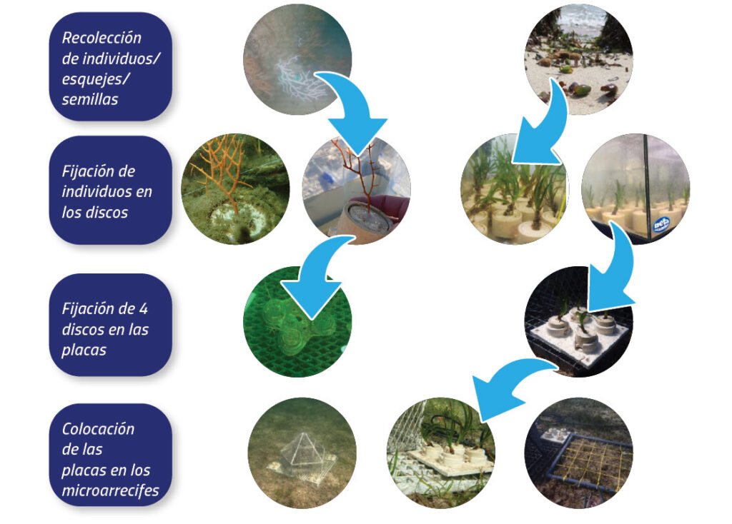
To test regeneration devices (LBUs) with pre-seeding techniques in different real environments. The application of these restoration techniques in different areas of the port Estartit will allow to obtain information on the viability of the organisms in several degraded habitats under different conditions
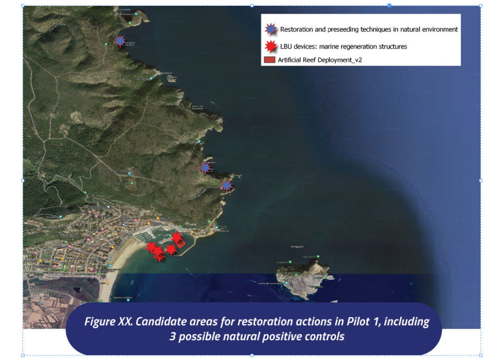
→ 25 regeneration structures will be installed in different areas of the port and monitoring with ROV and divers will be carried out to observe the effectiveness of the restoration and preseeding techniques. Physicochemical data, videos, biomass, biodiversity, CO2 capture are some of the information that is going to be obtained.
Deployment of a marine artificial reef taking advantage of the natural substrate that is formed by the electrolysis process together with a new design implementation based on the knowledge of OE in developing NbS solutions for marine environmental regeneration, creating new habitats and promoting the recruitment and colonization of different marine species.
To compare all of the restoration actions mentioned above in a degraded environment (Port Estartit) vs a natural environment (Cala Calella, natural space close to the port), establishing this last one as a positive control.
→ 1 to 3 regeneration structures will be installed in this natural area, established as a positive control. Preseeding and restoration techniques will be also carried out to compare both natural and degraded environments. The same monitoring system as in the port will be done in this place.
Public Engagement and Citizen Science
Within the framework of the project we are conducting in the Natural Park, various citizen science activities have been carried out. Some examples of these events include park cleaning tasks, promoting local development in protected areas, and more. These initiatives are coordinated by the regional institution, namely the Generalitat of Catalonia. For additional information, we invite you to visit the following link:” https://parcsnaturals.gencat.cat/es/detalls/Noticia/dia-europeu-parcs-medes”
Other citizen science groups in the area that could be involved, can be Institut en Ciencias del Mar (ICM), Consejo Superior de Investigaciones Científicas (CSIC).
Additionally, in 2024 will start the activity of the ESPAI MEDES: Which will be the center of reference and dissemination of the environmental, cultural and touristic values of the Natural Park, in its marine area. It will also become a promotional tool at the service of local economic revitalization. It will complement its activity with that of the Mediterranean Museum, which will be the reference facility for the terrestrial part of the park.
Institutional and legal framework
The designation of the Mediterranean ZEPA ES0000514 Marine space of l’Empordà, located in the Levantine-Balearic marine demarcation, it has been carried out based on the marine IBA1 ES411, adjusting its limits effectively and coherently in order to guarantee the proper management of this space and the favorable conservation of the seabirds that justify its incorporation into the Natura 2000 Network.
This marine ZEPA constitutes an important feeding area for numerous birds marine species included in Annex I of the Birds Directive (Directive 2009/147/EC) and in the annex IV of Law 42/2007, of December 13, on Natural Heritage and Biodiversity. It is also relevant for certain migratory seabirds regularly present in Spain. -not included in the previous annexes- and for other seabirds.
Relevant EU projects for the MPA pilot site
- LIFE ECOREST «establish nearly 30,000 hectares of deep marine habitats in Catalonia in an area of high ecological value)»(2020-2024)
- LIFE TER VELL-PLETERA «Restoration and organization of llacunes and coastal systems of the Baix Ter(1999-2003)»
- LIFE EMYSTER «Recovery of amphibis and Emys orbicularis habitat in Baix Ter (2005-2008)»
- LIFE PLETERA «Deurbanization and recovery of ecological functionality in the coastal systems of La Pletera (2014-2018)»
Scientific publications
Raquel, Modino & Pascual-Fernandez, Jose. (2011). 30 Años de protección: turismo y pesca en las Illes Medes.
Ros i Aragonès, Joandomènec; Gili, Josep M. «Four decades of research on the Medes Islands». Contributions to science, 2016, Vol. 11, Núm. 1, p. 75-83, https://raco.cat/index.php/Contributions/article/view/313114.
Bibliography
- Key Biodiversity Areas: keep nature thriving (2022, September) [Online]. Available: www.keybiodiversityareas.org
- Estructura i funcionament taula de congestió marítima del litoral del Baix Empordà, Generalitat Cataluña, 2018.
- Ros, J., & Gili, J. M. (2016). Four decades of research on the Medes Islands. Contributions to SCIENCE, 11, 75-83. doi:10.2436/20.7010.01.215
- Martín, P., Maynou, F., Stelzenmüller, V., & Sacanell, M. (2012). A small-scale fishery near a rocky littoral marine reserve in the northwestern Mediterranean (Medes Islands) after two decades of fishing prohibition. Scientia Marina, 76(3), 607-618